
Smithsonian Institution / US Geological Survey
Weekly Volcanic Activity Report, 30 April-6 May 2008
Managing Editor: Sally Sennert
Please cite this report as:
Global Volcanism Program, 2008. Report on Kīlauea (United States) (Sennert, S, ed.). Weekly Volcanic Activity Report, 30 April-6 May 2008. Smithsonian Institution and US Geological Survey. https://volcano.si.edu/showreport.cfm?gvpvar=GVP.WVAR20080430-332010
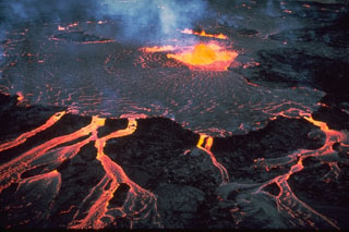
Based on visual observations from HVO and National Park Service (NPS) crews and web camera views, HVO reported that during 30 April-6 May lava flowed SE through a lava tube system underneath Kīlauea's Thanksgiving Eve Breakout (TEB) and rootless shield complex to the Waikupanaha ocean entry. On 4 May, lava flows from breakouts on the pali reached the coastal plain. Kīlauea summit earthquakes were located beneath the Halemaʻumaʻu crater, along the S-flank faults, and along the SW and E rift zones. The eruption from the vent in Halemaʻumaʻu Crater continued to produce white plumes with minor ash content that drifted mainly SW. During most nights incandescence was seen at the base of the plume. Seismic tremor was elevated. The sulfur dioxide emission rate was high and fluctuated between 540 and 1,250 tonnes per day during 30 April-5 May. The background rate was 150-200 tonnes per day.
Source: US Geological Survey Hawaiian Volcano Observatory (HVO)
Geological Summary. Kīlauea overlaps the E flank of the massive Mauna Loa shield volcano in the Island of Hawaiʻi. Eruptions are prominent in Polynesian legends; written documentation since 1820 records frequent summit and flank lava flow eruptions interspersed with periods of long-term lava lake activity at Halemaʻumaʻu crater in the summit caldera until 1924. The 3 x 5 km caldera was formed in several stages about 1,500 years ago and during the 18th century; eruptions have also originated from the lengthy East and Southwest rift zones, which extend to the ocean in both directions. About 90% of the surface of the basaltic shield volcano is formed of lava flows less than about 1,100 years old; 70% of the surface is younger than 600 years. The long-term eruption from the East Rift Zone between 1983 and 2018 produced lava flows covering more than 100 km2, destroyed hundreds of houses, and added new coastline.


 Kīlauea