
Smithsonian Institution / US Geological Survey
Weekly Volcanic Activity Report, 8 October-14 October 2008
Managing Editor: Sally Sennert
Please cite this report as:
Global Volcanism Program, 2008. Report on Dukono (Indonesia) (Sennert, S, ed.). Weekly Volcanic Activity Report, 8 October-14 October 2008. Smithsonian Institution and US Geological Survey. https://volcano.si.edu/showreport.cfm?gvpvar=GVP.WVAR20081008-268010
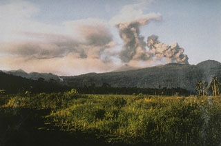
Based on analysis of satellite imagery, the Darwin VAAC reported that on 11 October an ash plume from Dukono rose to an altitude of 3 km (10,000 ft) a.s.l. and drifted about 110 km WNW.
Source: Darwin Volcanic Ash Advisory Centre (VAAC)
Geological Summary. The Dukono complex in northern Halmahera is on an edifice with a broad, low profile containing multiple peaks and overlapping craters. Almost continuous explosive eruptions, sometimes accompanied by lava flows, have occurred since 1933. During a major eruption in 1550 CE, a lava flow filled in the strait between Halmahera and the Gunung Mamuya cone, 10 km NE. Malupang Wariang, 1 km SW of the summit crater complex, contains a 700 x 570 m crater that has also had reported eruptions.


 Dukono