Report on Gamkonora (Indonesia) — 18 March-24 March 2009
Smithsonian Institution / US Geological Survey
Weekly Volcanic Activity Report, 18 March-24 March 2009
Managing Editor: Sally Sennert.
Please cite this report as:
Global Volcanism Program, 2009. Report on Gamkonora (Indonesia) (Sennert, S, ed.). Weekly Volcanic Activity Report, 18 March-24 March 2009. Smithsonian Institution and US Geological Survey.
Gamkonora
Indonesia
1.38°N, 127.53°E; summit elev. 1635 m
All times are local (unless otherwise noted)
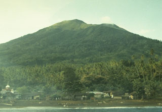
On 23 March, CVGHM lowered the Alert Level for Gamkonora from 2 to 1 (on a scale of 1-4) based on visual observations and decreased seismicity since January. Diffuse white plumes rose 50-150 m above the crater. Residents and visitors were reminded not to approach or climb the crater.
Geological Summary. The shifting of eruption centers on Gamkonora, the highest peak of Halmahera, has produced an elongated series of summit craters along a N-S trending rift. Youthful-looking lava flows originate near the cones of Gunung Alon and Popolojo, south of Gamkonora. Since its first recorded eruption in the 16th century, typical activity has been small-to-moderate explosive eruptions. Its largest recorded eruption, in 1673, was accompanied by tsunamis that inundated villages.
Source: Pusat Vulkanologi dan Mitigasi Bencana Geologi (PVMBG, also known as CVGHM)