Report on NW Rota-1 (United States) — 15 April-21 April 2009
Smithsonian Institution / US Geological Survey
Weekly Volcanic Activity Report, 15 April-21 April 2009
Managing Editor: Sally Sennert.
Please cite this report as:
Global Volcanism Program, 2009. Report on NW Rota-1 (United States) (Sennert, S, ed.). Weekly Volcanic Activity Report, 15 April-21 April 2009. Smithsonian Institution and US Geological Survey.
NW Rota-1
United States
14.601°N, 144.775°E; summit elev. -455 m
All times are local (unless otherwise noted)
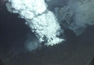
According to a news article from 20 April, scientists investigating NW Rota-1 during the previous two weeks observed the volcano erupting about 520 m below the ocean's surface. Measurements indicated that the volcano had grown about 40 m since 2006. One scientist observed billowing yellow and white sulfur clouds, carbon dioxide bubbles streaming out of the vent, and "ash and pebble-sized rocks raining out of the plume."
Geological Summary. A submarine volcano detected during a 2003 NOAA bathymetric survey of the Mariana Island arc was found to be hydrothermally active and named NW Rota-1. The basaltic to basaltic andesite seamount rises to within 517 m of the ocean surface SW of Esmeralda Bank, 64 km NW of Rota Island and ~100 km N of Guam. When Northwest Rota-1 was revisited in 2004, a minor submarine eruption from a vent named Brimstone Pit on the upper south flank about 40 m below the summit intermittently ejected a plume several hundred meters high containing ash, rock particles, and molten sulfur droplets that adhered to the surface of the remotely operated submersible vehicle. The active vent was funnel-shaped, about 20 m wide and 12 m deep. Prominent structural lineaments about a kilometer apart cut across the summit of the edifice and down the NE and SW flanks.
Source: GuamPDN - Pacific Daily News