
Smithsonian Institution / US Geological Survey
Weekly Volcanic Activity Report, 2 December-8 December 2009
Managing Editor: Sally Sennert
Please cite this report as:
Global Volcanism Program, 2009. Report on San Cristobal (Nicaragua) (Sennert, S, ed.). Weekly Volcanic Activity Report, 2 December-8 December 2009. Smithsonian Institution and US Geological Survey. https://volcano.si.edu/showreport.cfm?gvpvar=GVP.WVAR20091202-344020
Based on analyses of satellite imagery, the Washington VAAC reported that on 6 December a gas-and-steam plume from San Cristóbal, possibly containing ash, drifted SW. The VAAC also noted smoke from local fires.
Source: Washington Volcanic Ash Advisory Center (VAAC)
Geological Summary. The San Cristóbal volcanic complex, consisting of five principal volcanic edifices, forms the NW end of the Marrabios Range. The symmetrical 1745-m-high youngest cone, named San Cristóbal (also known as El Viejo), is Nicaragua's highest volcano and is capped by a 500 x 600 m wide crater. El Chonco, with several flank lava domes, is located 4 km W of San Cristóbal; it and the eroded Moyotepe volcano, 4 km NE of San Cristóbal, are of Pleistocene age. Volcán Casita, containing an elongated summit crater, lies immediately east of San Cristóbal and was the site of a catastrophic landslide and lahar in 1998. The Plio-Pleistocene La Pelona caldera is located at the eastern end of the complex. Historical eruptions from San Cristóbal, consisting of small-to-moderate explosive activity, have been reported since the 16th century. Some other 16th-century eruptions attributed to Casita volcano are uncertain and may have been from other Marrabios Range volcanoes.


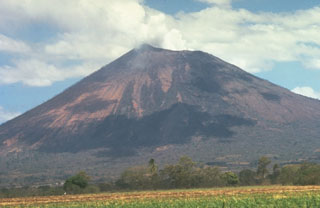 San Cristobal