
Smithsonian Institution / US Geological Survey
Weekly Volcanic Activity Report, 13 January-19 January 2010
Managing Editor: Sally Sennert
Please cite this report as:
Global Volcanism Program, 2010. Report on Gaua (Vanuatu) (Sennert, S, ed.). Weekly Volcanic Activity Report, 13 January-19 January 2010. Smithsonian Institution and US Geological Survey. https://volcano.si.edu/showreport.cfm?gvpvar=GVP.WVAR20100113-257020
On 13 January, Vanuatu Geohazards Observatory reported that ash emissions that had become denser and darker on 14 December continued. Ashfall persisted in the W part of the island and satellite imagery showed gas emissions. The Vanuatu Volcano Alert Level (VVAL) remained at 2 (on a scale of 0-4).
Source: Vanuatu Meteorology and Geohazards Department (VMGD)
Geological Summary. The roughly 20-km-diameter Gaua Island, also known as Santa Maria, consists of a basaltic-to-andesitic stratovolcano with an 6 x 9 km summit caldera. Small vents near the caldera rim fed Pleistocene lava flows that reached the coast on several sides of the island; littoral cones were formed where these lava flows reached the ocean. Quiet collapse that formed the roughly 700-m-deep caldera was followed by extensive ash eruptions. The active Mount Garet (or Garat) cone in the SW part of the caldera has three pit craters across the summit area. Construction of Garet and other small cinder cones has left a crescent-shaped lake. Eruptions have been frequent since the onset of activity from a vent high on the SE flank in 1962.


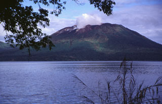 Gaua
Gaua