
Smithsonian Institution / US Geological Survey
Weekly Volcanic Activity Report, 7 July-13 July 2010
Managing Editor: Sally Sennert
Please cite this report as:
Global Volcanism Program, 2010. Report on Karymsky (Russia) (Sennert, S, ed.). Weekly Volcanic Activity Report, 7 July-13 July 2010. Smithsonian Institution and US Geological Survey. https://volcano.si.edu/showreport.cfm?gvpvar=GVP.WVAR20100707-300130
KVERT reported that during 2-9 July seismic activity from Karymsky was above background levels and suggested that possible ash plumes rose to an altitude of 2 km (6,500 ft) a.s.l. A thermal anomaly was detected in satellite imagery on most days; cloud cover occasionally prevented views of the volcano. On 7 July ash plumes drifted 20 km S. Based on information from the Yelizovo Airport (UHPP), the Tokyo VAAC reported that on 13 July an ash plume rose to an altitude of 2.7 km (9,000 ft) a.s.l. and drifted W. The Aviation Color Code level remained at Orange.
Sources: Tokyo Volcanic Ash Advisory Center (VAAC), Kamchatkan Volcanic Eruption Response Team (KVERT)
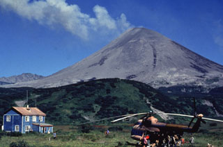
Geological Summary. Karymsky is a symmetrical stratovolcano constructed within a 5-km-wide caldera that formed during the early Holocene. The caldera cuts the S side of the Pleistocene Dvor volcano and is located outside the N margin of the large mid-Pleistocene Polovinka caldera, which contains the smaller Akademia Nauk and Odnoboky calderas. Most seismicity preceding Karymsky eruptions originated beneath Akademia Nauk caldera, located immediately south. The enclosing caldera formed about 7,600-7,700 radiocarbon years ago; construction of the stratovolcano began about 2,000 years later. The latest eruptive period began about 500 years ago, following a 2,300 years of quiescence. Much of the cone is covered by lava flows less than 200 years old. Recorded eruptions have been Vulcanian or Vulcanian-Strombolian with moderate explosive activity and occasional lava flows from the summit crater.


 Karymsky