
Smithsonian Institution / US Geological Survey
Weekly Volcanic Activity Report, 21 July-27 July 2010
Managing Editor: Sally Sennert
Please cite this report as:
Global Volcanism Program, 2010. Report on Turrialba (Costa Rica) (Sennert, S, ed.). Weekly Volcanic Activity Report, 21 July-27 July 2010. Smithsonian Institution and US Geological Survey. https://volcano.si.edu/showreport.cfm?gvpvar=GVP.WVAR20100721-345070
Based on web camera views of Turrialba, the Washington VAAC reported that on 24 July a plume of steam, gas, and ash drifted W. Over the next three hours the plume became more diffuse and steam-rich.
Source: Washington Volcanic Ash Advisory Center (VAAC)
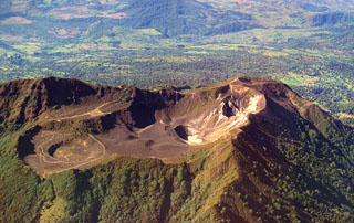
Geological Summary. Turrialba, the easternmost of Costa Rica's Holocene volcanoes, is a large vegetated basaltic-to-dacitic stratovolcano located across a broad saddle NE of Irazú volcano overlooking the city of Cartago. The massive edifice covers an area of 500 km2. Three well-defined craters occur at the upper SW end of a broad 800 x 2200 m summit depression that is breached to the NE. Most activity originated from the summit vent complex, but two pyroclastic cones are located on the SW flank. Five major explosive eruptions have occurred during the past 3500 years. A series of explosive eruptions during the 19th century were sometimes accompanied by pyroclastic flows. Fumarolic activity continues at the central and SW summit craters.


 Turrialba