Report on Callaqui (Chile) — 28 December-3 January 2012
Smithsonian Institution / US Geological Survey
Weekly Volcanic Activity Report, 28 December-3 January 2012
Managing Editor: Sally Sennert.
Please cite this report as:
Global Volcanism Program, 2011. Report on Callaqui (Chile) (Sennert, S, ed.). Weekly Volcanic Activity Report, 28 December-3 January 2012. Smithsonian Institution and US Geological Survey.
Callaqui
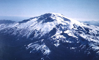
Chile
37.92°S, 71.45°W; summit elev. 3164 m
All times are local (unless otherwise noted)
Based on a pilot observation, the Buenos Aires VAAC reported that the top of an ash plume from Callaqui was at 3 km (10,000 ft) a.s.l. on 2 January. Ash was not detected in satellite imagery under clear skies.
Geological Summary. The late-Pleistocene to Holocene Callaqui stratovolcano has a profile of an overturned canoe, due to its construction along an 11-km-long, SW-NE fissure above a 1.2-0.3 million year old Pleistocene edifice. The ice-capped, basaltic andesite volcano contains well-preserved cones and lava flows, which have traveled up to 14 km. Small craters 100-500 m in diameter are primarily found along a fissure extending down the SW flank. Intense solfataric activity occurs at the southern portion of the summit; in 1966 and 1978, red glow was observed in fumarolic areas (Moreno 1985, pers. comm.). Periods of intense fumarolic activity have dominated; few historical eruptions are known. An explosive eruption was reported in 1751, there were uncertain accounts of eruptions in 1864 and 1937, and a small phreatic ash emission was noted in 1980.