Report on Iliamna (United States) — 7 March-13 March 2012
Smithsonian Institution / US Geological Survey
Weekly Volcanic Activity Report, 7 March-13 March 2012
Managing Editor: Sally Sennert.
Please cite this report as:
Global Volcanism Program, 2012. Report on Iliamna (United States) (Sennert, S, ed.). Weekly Volcanic Activity Report, 7 March-13 March 2012. Smithsonian Institution and US Geological Survey.
Iliamna
United States
60.032°N, 153.09°W; summit elev. 3053 m
All times are local (unless otherwise noted)
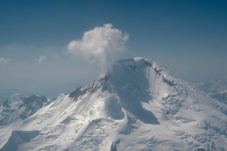
AVO reported that earthquake activity had steadily increased at Iliamna during the past three months. On 9 March AVO increased the Alert Level to Advisory and the Aviation Color Code to Yellow. The report noted that the current activity was characterized by numerous earthquakes that had varied in their number and magnitude over the past week.
Geological Summary. Iliamna is a prominent glacier-covered stratovolcano in Lake Clark National Park on the western side of Cook Inlet, about 225 km SW of Anchorage. Its flat-topped summit is flanked on the south, along a 5-km-long ridge, by the North and South Twin Peaks lava dome complexes. The Johnson Glacier dome complex lies on the NE flank. Steep headwalls on the S and E flanks expose an inaccessible cross-section of the volcano. Major glaciers radiate from the summit, and valleys below the summit contain debris avalanche and lahar deposits. Only a few major Holocene explosive eruptions have occurred from the deeply dissected volcano, which lacks a distinct crater. Most of the reported eruptions may represent plumes from vigorous fumaroles E and SE of the summit, which are often mistaken for eruption columns (Miller et al., 1998). Eruptions producing pyroclastic flows have been dated to 1778-1779 and 1876 CE. Elevated seismicity accompanying dike emplacement beneath the volcano was recorded in 1996.
Source: US Geological Survey Alaska Volcano Observatory (AVO)