
Smithsonian Institution / US Geological Survey
Weekly Volcanic Activity Report, 30 March-5 April 2016
Managing Editor: Sally Sennert
Please cite this report as:
Global Volcanism Program, 2016. Report on Telica (Nicaragua) (Sennert, S, ed.). Weekly Volcanic Activity Report, 30 March-5 April 2016. Smithsonian Institution and US Geological Survey. https://volcano.si.edu/showreport.cfm?gvpvar=GVP.WVAR20160330-344040
On 30 March INETER reported that micro-seismicity at Telica remained high and was characterized by small, high-energy earthquakes. Incandescence emanated from the crater floor. On 4 April SINAPRED noted that seismicity continued at a high level and warned the public to stay away from the crater.
Sources: Instituto Nicaragüense de Estudios Territoriales (INETER), Sistema Nacional para la Prevención, Mitigación y Atención de Desastres (SINAPRED)
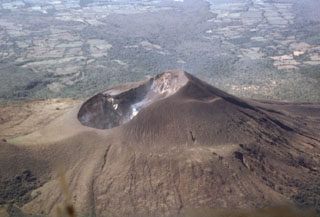
Geological Summary. Telica, one of Nicaragua's most active volcanoes, has erupted frequently since the beginning of the Spanish era. This volcano group consists of several interlocking cones and vents with a general NW alignment. Sixteenth-century eruptions were reported at symmetrical Santa Clara volcano at the SW end of the group. However, its eroded and breached crater has been covered by forests throughout historical time, and these eruptions may have originated from Telica, whose upper slopes in contrast are unvegetated. The steep-sided cone of Telica is truncated by a 700-m-wide double crater; the southern crater, the source of recent eruptions, is 120 m deep. El Liston, immediately E, has several nested craters. The fumaroles and boiling mudpots of Hervideros de San Jacinto, SE of Telica, form a prominent geothermal area frequented by tourists, and geothermal exploration has occurred nearby.


 Telica