Report on Bezymianny (Russia) — 21 June-27 June 2017
Smithsonian Institution / US Geological Survey
Weekly Volcanic Activity Report, 21 June-27 June 2017
Managing Editor: Sally Sennert.
Please cite this report as:
Global Volcanism Program, 2017. Report on Bezymianny (Russia) (Sennert, S, ed.). Weekly Volcanic Activity Report, 21 June-27 June 2017. Smithsonian Institution and US Geological Survey.
Bezymianny
Russia
55.972°N, 160.595°E; summit elev. 2882 m
All times are local (unless otherwise noted)
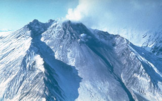
KVERT reported that a powerful explosion at Bezymianny on 16 June generated an ash plume that rose as high as 12 km (39,400 ft) a.s.l. and drifted 700 km E and SE. Nighttime incandescence from the lava dome was observed at night afterwards, and a lava flow emerged from the W flank of the dome. A thermal anomaly was identified daily in satellite images during 16-23 June. The Aviation Color Code remained at Orange (the second highest level on a four-color scale).
Geological Summary. The modern Bezymianny, much smaller than its massive neighbors Kamen and Kliuchevskoi on the Kamchatka Peninsula, was formed about 4,700 years ago over a late-Pleistocene lava-dome complex and an edifice built about 11,000-7,000 years ago. Three periods of intensified activity have occurred during the past 3,000 years. The latest period, which was preceded by a 1,000-year quiescence, began with the dramatic 1955-56 eruption. This eruption, similar to that of St. Helens in 1980, produced a large open crater that was formed by collapse of the summit and an associated lateral blast. Subsequent episodic but ongoing lava-dome growth, accompanied by intermittent explosive activity and pyroclastic flows, has largely filled the 1956 crater.