
Smithsonian Institution / US Geological Survey
Weekly Volcanic Activity Report, 27 June-3 July 2018
Managing Editor: Sally Sennert
Please cite this report as:
Global Volcanism Program, 2018. Report on Great Sitkin (United States) (Sennert, S, ed.). Weekly Volcanic Activity Report, 27 June-3 July 2018. Smithsonian Institution and US Geological Survey. https://volcano.si.edu/showreport.cfm?gvpvar=GVP.WVAR20180627-311120
AVO reported that after the brief explosion at Great Sitkin on 10 June seismicity gradually declined to background levels. On 27 June AVO lowered the Volcano Alert Level to Normal and the Aviation Color Code to Green.
Source: US Geological Survey Alaska Volcano Observatory (AVO)
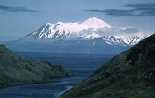
Geological Summary. The Great Sitkin volcano forms much of the northern side of Great Sitkin Island. A younger volcano capped by a small, 0.8 x 1.2 km ice-filled summit caldera was constructed within a large late-Pleistocene or early Holocene scarp formed by massive edifice failure that truncated an older edifice and produced a submarine debris avalanche. Deposits from this and an even older debris avalanche from a source to the south cover a broad area of the ocean floor north of the volcano. The summit lies along the eastern rim of the younger collapse scarp. Deposits from an earlier caldera-forming eruption of unknown age cover the flanks of the island to a depth up to 6 m. The small younger caldera was partially filled by lava domes emplaced in 1945 and 1974, and five small older flank lava domes, two of which lie on the coastline, were constructed along northwest- and NNW-trending lines. Hot springs, mud pots, and fumaroles occur near the head of Big Fox Creek, south of the volcano. Eruptions have been recorded since the late-19th century.


 Great Sitkin