Report on Cuicocha (Ecuador) — 10 October-16 October 2018
Smithsonian Institution / US Geological Survey
Weekly Volcanic Activity Report, 10 October-16 October 2018
Managing Editor: Sally Sennert.
Please cite this report as:
Global Volcanism Program, 2018. Report on Cuicocha (Ecuador) (Sennert, S, ed.). Weekly Volcanic Activity Report, 10 October-16 October 2018. Smithsonian Institution and US Geological Survey.
Cuicocha
Ecuador
0.308°N, 78.364°W; summit elev. 3246 m
All times are local (unless otherwise noted)
IG reported that, after an earthquake swarm consisting of 62 volcano-tectonic events during 2-3 October, seismicity at Cuicocha returned to background levels on 4 October. Carbon dioxide levels were normal, and deformation data did not show any anomalies.
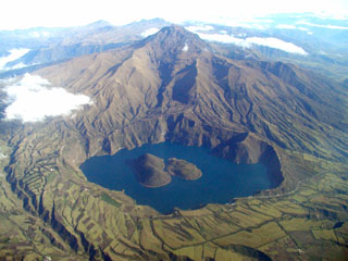
Geological Summary. The scenic lake-filled Cuicocha caldera is located at the southern foot of the sharp-peaked Pleistocene Cotacachi stratovolcano about 100 km N of Quito. Both Cotacachi and Cuicocha were constructed along the Otavalo-Umpalá fracture zone. Eruptive activity began about 4500 years ago and continued until about 1300 years ago. The 3-km-wide, steep-walled caldera was created during a major explosive eruption about 3100 years ago that produced nearly 5 km3 of pyroclastic-flow and fall deposits. Four intra-caldera lava domes form two steep-sided forested islands in the 148-m-deep lake. A pre-caldera lava dome is situated on the outer E side of the caldera. Pyroclastic-flow deposits cover wide areas around the low-rimmed caldera, primarily to the east. Gas emission continues from several locations in the caldera lake.
Source: Instituto Geofísico-Escuela Politécnica Nacional (IG-EPN)