Report on Alaid (Russia) — 11 September-17 September 2019
Smithsonian Institution / US Geological Survey
Weekly Volcanic Activity Report, 11 September-17 September 2019
Managing Editor: Sally Sennert.
Please cite this report as:
Global Volcanism Program, 2019. Report on Alaid (Russia) (Sennert, S, ed.). Weekly Volcanic Activity Report, 11 September-17 September 2019. Smithsonian Institution and US Geological Survey.
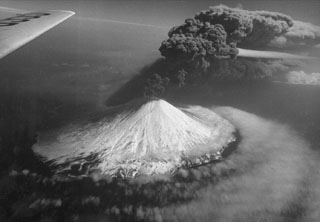
Alaid
Russia
50.861°N, 155.565°E; summit elev. 2285 m
All times are local (unless otherwise noted)
The Tokyo VAAC reported that on 11 September an ash plume from Alaid identified in satellite images rose to an altitude of 3 km (10,000 ft) a.s.l. and drifted SE.
Geological Summary. The highest and northernmost volcano of the Kuril Islands, Alaid is a symmetrical stratovolcano when viewed from the north, but has a 1.5-km-wide summit crater that is breached open to the south. This basaltic to basaltic andesite volcano is the northernmost of a chain constructed west of the main Kuril archipelago. Numerous pyroclastic cones are present the lower flanks, particularly on the NW and SE sides, including an offshore cone formed during the 1933-34 eruption. Strong explosive eruptions have occurred from the summit crater beginning in the 18th century. Reports of eruptions in 1770, 1789, 1821, 1829, 1843, 1848, and 1858 were considered incorrect by Gorshkov (1970). Explosive eruptions in 1790 and 1981 were among the largest reported in the Kuril Islands.