Report on Lateiki (Tonga) — 9 October-15 October 2019
Smithsonian Institution / US Geological Survey
Weekly Volcanic Activity Report, 9 October-15 October 2019
Managing Editor: Sally Sennert.
Please cite this report as:
Global Volcanism Program, 2019. Report on Lateiki (Tonga) (Sennert, S, ed.). Weekly Volcanic Activity Report, 9 October-15 October 2019. Smithsonian Institution and US Geological Survey.
Lateiki
Tonga
19.18°S, 174.87°W; summit elev. 43 m
All times are local (unless otherwise noted)
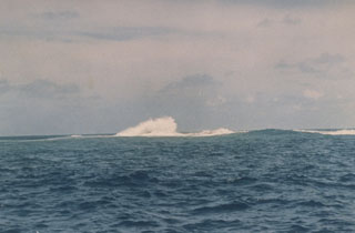
According to news articles the Tonga Geological Services Office of the Ministry of Lands and Natural Resources stated that several observations indicating a possible eruption at Metis Shoal, also known as Lateiki, were reported during 13-15 October. Real Tonga pilots flying between Tongatapu and Vava'u observed the intermittent plumes rising to 4.6-5.2 km (15,000-17,000 ft) a.s.l. and drifting N on 15 October. Ash in the plumes was not identifiable according to the Wellington VAAC.
Geological Summary. Lateiki, previously known as Metis Shoal, is a submarine volcano midway between the islands of Kao and Late that has produced a series of ephemeral islands since the first confirmed activity in the mid-19th century. An island, perhaps not in eruption, was reported in 1781 and subsequently eroded away. During periods of inactivity following 20th-century eruptions, waves have been observed to break on rocky reefs or sandy banks with depths of 10 m or less. Dacitic tuff cones formed during the eruptions in 1967 and 1979 were soon eroded beneath the ocean surface. An eruption in 1995 produced an island with a diameter of 280 m and a height of 43 m following growth of a lava dome above the surface.
Sources: Wellington Volcanic Ash Advisory Center (VAAC), Matangi Tonga Online, Matangi Tonga Online