Report on Nevados de Chillan (Chile) — 16 September-22 September 2020
Smithsonian Institution / US Geological Survey
Weekly Volcanic Activity Report, 16 September-22 September 2020
Managing Editor: Sally Sennert.
Please cite this report as:
Global Volcanism Program, 2020. Report on Nevados de Chillan (Chile) (Sennert, S, ed.). Weekly Volcanic Activity Report, 16 September-22 September 2020. Smithsonian Institution and US Geological Survey.
Nevados de Chillan
Chile
36.868°S, 71.378°W; summit elev. 3180 m
All times are local (unless otherwise noted)
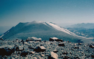
On 22 September SERNAGEOMIN reported that lava continued to advance down Nevados de Chillán’s NNE flank. Gas emissions and occasional explosions were also recorded. The Alert Level remained at Yellow, the second lowest level on a four-color scale, and residents were reminded not to approach the crater within 3 km. ONEMI stated that Alert Level Yellow (the middle level on a three-color scale) remained in place for the communities of Pinto and Coihueco, noting that as of 16 June the public should stay at least 3 km away from the crater on the SW flank and 5 km away on the NE flank.
Geological Summary. The compound volcano of Nevados de Chillán is one of the most active of the Central Andes. Three late-Pleistocene to Holocene stratovolcanoes were constructed along a NNW-SSE line within three nested Pleistocene calderas, which produced ignimbrite sheets extending more than 100 km into the Central Depression of Chile. The dominantly andesitic Cerro Blanco (Volcán Nevado) stratovolcano is located at the NW end of the massif. Volcán Viejo (Volcán Chillán), which was the main active vent during the 17th-19th centuries, occupies the SE end. The Volcán Nuevo lava-dome complex formed during 1906-1945 on the NW flank of Viejo. The Volcán Arrau dome complex was then constructed on the SE side of Volcán Nuevo between 1973 and 1986, and eventually exceeded its height. Smaller domes or cones are present in the 5-km valley between the two major edifices.
Sources: Servicio Nacional de Geología y Minería (SERNAGEOMIN), Oficina Nacional de Emergencia-Ministerio del Interior (ONEMI)