Report on La Palma (Spain) — 15 December-21 December 2021
Smithsonian Institution / US Geological Survey
Weekly Volcanic Activity Report, 15 December-21 December 2021
Managing Editor: Sally Sennert.
Please cite this report as:
Global Volcanism Program, 2021. Report on La Palma (Spain) (Sennert, S, ed.). Weekly Volcanic Activity Report, 15 December-21 December 2021. Smithsonian Institution and US Geological Survey.
La Palma
Spain
28.57°N, 17.83°W; summit elev. 2426 m
All times are local (unless otherwise noted)
Observations at La Palma on 15 December showed no lava flowing from vents at the W base of the main cone, from tubes, or at the lava delta in the Las Hoyas area. During 15-20 December tremor levels were at background levels and seismicity was very low at all depths. Sporadic gas emissions rose from the vents and from cooling lava flows. Small collapses from the walls of the main and secondary cone craters were visible through the week. Sulfur dioxide levels varied between extremely low and medium values (less than 5 to 999 tons per day) consistent with a cooling and degassing lava flow field. Even though air quality levels had improved overall, a few measurements of diffuse carbon dioxide emissions showed levels around 9 times average background. Authorities warned the public to exercise caution in areas surrounding the flow field due to volcanic gases in the area and noted that lava flows, although cooling, remained at high temperatures.
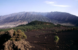
Geological Summary. The 47-km-long wedge-shaped island of La Palma, the NW-most of the Canary Islands, is composed of two large volcanic centers. The older northern one is cut by the steep-walled Caldera Taburiente, one of several massive collapse scarps produced by edifice failure to the SW. On the south, the younger Cumbre Vieja volcano is one of the most active in the Canaries. The elongated volcano dates back to about 125,000 years ago and is oriented N-S. Eruptions during the past 7,000 years have formed abundant cinder cones and craters along the axis, producing fissure-fed lava flows that descend steeply to the sea. Eruptions recorded since the 15th century have produced mild explosive activity and lava flows that damaged populated areas. The southern tip of the island is mantled by a broad lava field emplaced during the 1677-1678 eruption. Lava flows also reached the sea in 1585, 1646, 1712, 1949, 1971, and 2021.
Sources: Instituto Volcanológico de Canarias (INVOLCAN), Gobierno de Canaries, Instituto Geográfico Nacional (IGN)