Report on Rincon de la Vieja (Costa Rica) — 24 May-30 May 2023
Smithsonian Institution / US Geological Survey
Weekly Volcanic Activity Report, 24 May-30 May 2023
Managing Editor: Sally Sennert.
Please cite this report as:
Global Volcanism Program, 2023. Report on Rincon de la Vieja (Costa Rica) (Sennert, S, ed.). Weekly Volcanic Activity Report, 24 May-30 May 2023. Smithsonian Institution and US Geological Survey.
Rincon de la Vieja
Costa Rica
10.8314°N, 85.3364°W; summit elev. 1729 m
All times are local (unless otherwise noted)
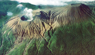
OVSICORI-UNA reported that phreatic explosions continued at Rincón de la Vieja during 24-30 May. Moderate phreatic events at 1815 and 1830 on 24 May produced voluminous gas-and-steam plumes possibly containing some lake sediments that rose about 2.5 km above the crater rim. Aerial photos from that day showed fairly low lake water levels. The water was a milky gray color and was convecting, partly due to of subaqueous fumaroles. White deposits comprised of altered rocks blanketed the active crater from eruptive activity in recent days. A strong phreatic explosion at 1435 on 25 May produced an ash, gas, and steam plume that drifted NW. Small phreatic events were recorded at 2230 on 25 May and at 0453 and 0704 on 26 May. During a 26 May overflight the lake water level was observed to have significantly dropped compared to 24 May. Phreatic eruptions were recorded at 1357 and 2348 on 26 May and at 0221 and 0632 on 27 May. An energetic eruption at 2135 on 27 May ejected incandescent material and generated a plume mainly comprised of water vapor that rose 3.5-4 km above the crater rim. A significant lahar descended the Pénjamo River and possibly other drainages. On 29 May OVSICORI-UNA noted that the volcano was very active with frequent explosive eruptions. At 0244 an explosion ejected incandescent material and generated a lahar in the Pénjamo River.
Geological Summary. Rincón de la Vieja is a volcanic complex in the Guanacaste Range of NW Costa Rica. Sometimes referred to as the Rincon de la Vieja-Santa María Volcanic Complex, it consists of a slightly arcuate 20-km-long ridge of 12 craters and pyroclastic cones constructed within the 15-km-wide early Pleistocene Guachipelín caldera, whose rim is exposed on the south side. Sometimes known as the "Colossus of Guanacaste," it has an estimated volume of 130 km3 and contains at least nine major eruptive centers. The Santa María cone, the highest peak of the complex, is located on the E side of the ridge and has a lake within the 400-m-diameter crater. A Plinian eruption producing the 0.25 km3 Río Blanca tephra about 3,500 years ago was the last major magmatic eruption. All subsequent eruptions, including numerous reported eruptions possibly dating back to the 16th century, have been from the active crater, near the center of the complex, with an acidic 300-m-diameter lake.
Source: Observatorio Vulcanologico y Sismologico de Costa Rica-Universidad Nacional (OVSICORI-UNA)