Image GVP-06102

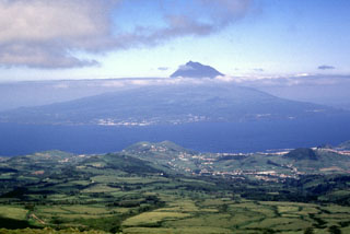
The conical Pico stratovolcano rising above the clouds is seen here from Fayal Island to the northwest. The 46-km-long Pico Island can be broadly separated into the Pico stratovolcano in the west, the Planalto da Achada fissure zone in the east (a roughly 30-km-long linear ridge of fissures and cones), and the Topo-Lajes volcano in the south. Pico volcano is capped by a 560-m-wide summit crater that contains a small steep-sided cone visible on the left side of the summit in this image. Recent eruptions have been recorded from the flanks of Pico and in the Planalto da Achada fissure zone.
Photo by Rick Wunderman, 1997 (Smithsonian Institution).
![]() This image is made available under the Public Domain Dedication CC0 license, but proper attribution is appreciated.
This image is made available under the Public Domain Dedication CC0 license, but proper attribution is appreciated.
Keywords: stratovolcano
Pico