Image GVP-07379

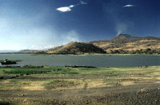
Volcán de San Diego (upper right) is seen here from the south at the outlet of Lake Güija. The lake formed after lava flows from San Diego blocked the channel of the Desagüe river. Cerro el Tule (left) lies across a narrow channel from the lower flanks of San Diego. Cerro el Tule contains a summit crater and is one of the many cones of the San Diego volcanic field.
Photo by Giuseppina Kysar, 1999 (Smithsonian Institution).
![]() This image is made available under the Creative Commons BY-NC-ND 4.0 license terms.
This image is made available under the Creative Commons BY-NC-ND 4.0 license terms.
Keywords: scoria cone | volcanic field
San Diego