Image GVP-09588

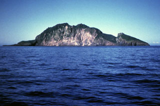
A steep, arcuate cliff drops nearly 300 m to the coast on the western side of Koniuji Island. This small, 1 x 1.5 km wide island, located between Atka Island and Kasatochi volcano, is the emergent top of a mostly-submarine volcano. A NE-trending fault is visible on the SE side of the island (right).
Photo by E. Bailey, 1982 (U.S. Fish and Wildlife Service).
![]() This image is made available as a Public Domain Work, but proper attribution is appreciated.
This image is made available as a Public Domain Work, but proper attribution is appreciated.
Koniuji