Image GVP-10993

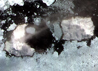
Thule (left) and Cook (right) islands are seen surrounded by ice floes in this ASTER satellite image. Douglas Strait, the ice-free area in the center of the image, is underlain by a 4.3 x 4.8 km wide caldera between the two volcanic islands. A third stratovolcano forms Bellingshausen Island, just out of view to the right. The Thule Islands lie at the southern end of the South Sandwich island arc bordering the Scotia Sea and consist of three stratovolcanoes constructed along an E-W-trending line.
ASTER satellite image, 2003 (National Aeronautical and Space Administration, courtesy of ASTER science team).
![]() This image is made available under the Creative Commons BY-NC 4.0 license terms.
This image is made available under the Creative Commons BY-NC 4.0 license terms.
Southern Thule