Image GVP-11691

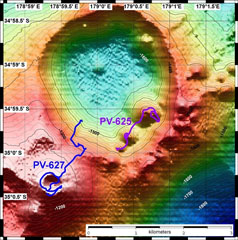
A bathymetric map of Healy submarine volcano is overlain by dive tracks of the submersible vehicle Pisces V. Dive depths range from 1,120 to 1,490 m. The resolution of the bathymetry data is 25 m, and the contour interval is 20 m. Roughly 600-year-old pumice deposits found on the shores of North Island, New Zealand, originated from Healy. The bathymetry data were obtained during a 2005 New Zealand-American NOAA Ocean Explorer research expedition to the Kermadec Arc.
Image courtesy of New Zealand-American Submarine Ring of Fire 2005 Exploration, NOAA Vents Program.
![]() This image is made available as a Public Domain Work, but proper attribution is appreciated.
This image is made available as a Public Domain Work, but proper attribution is appreciated.
Keywords: submarine volcano | stratovolcano | remote sensing | technology | DEM | map | bathymetry
Healy