Image GVP-12556

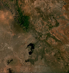
Cones, maars, lava flows, and craters of the Mega Basalt Field located along the Ethiopia-Kenya border are visible across this December 2020 Planet Labs satellite image mosaic (N at the top). It is located near the villages Mega and Megado and covers an area of approximately 1,400 km2. Large lava flows were produced from scoria cones and spatter ramparts, and the largest Maar is El Sod (top right), reaching 2.3 km in diameter and 0.41 km deep.
Satellite image courtesy of Planet Labs Inc., 2020 (https://www.planet.com/).
Copyrighted image used with permission. All Rights Reserved. Contact photographer for any usage requests.
Keywords: volcanic field | maar | scoria cone | lava flow
Mega Volcanic Field