Report on Irazu (Costa Rica) — February 1991
Bulletin of the Global Volcanism Network, vol. 16, no. 2 (February 1991)
Managing Editor: Lindsay McClelland.
Irazu (Costa Rica) Seismicity declines
Please cite this report as:
Global Volcanism Program, 1991. Report on Irazu (Costa Rica) (McClelland, L., ed.). Bulletin of the Global Volcanism Network, 16:2. Smithsonian Institution. https://doi.org/10.5479/si.GVP.BGVN199102-345060
Irazu
Costa Rica
9.979°N, 83.852°W; summit elev. 3436 m
All times are local (unless otherwise noted)
The seismic swarm that began 2 January continued through late February, but seismicity decreased to three small recorded events daily by the end of the month.
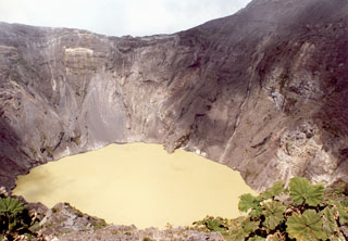
Geological Summary. The massive Irazú volcano in Costa Rica, immediately E of the capital city of San José, covers an area of 500 km2 and is vegetated to within a few hundred meters of its broad summit crater complex. At least 10 satellitic cones are located on its S flank. No lava effusion is known since the eruption of the Cervantes lava flows from S-flank vents about 14,000 years ago, and all known Holocene eruptions have been explosive. The focus of eruptions at the summit crater complex has migrated to the W towards the main crater, which contains a small lake. The first well-documented eruption occurred in 1723, and frequent explosive eruptions have occurred since. Ashfall from the last major eruption during 1963-65 caused significant disruption to San José and surrounding areas. Phreatic activity reported in 1994 may have been a landslide event from the fumarolic area on the NW summit (Fallas et al., 2018).
Information Contacts: R. Barquero, ICE; Mario Fernández, Escuela Centroamericana de Geología, Univ de Costa Rica.

