Report on Sarigan (United States) — June 1992
Bulletin of the Global Volcanism Network, vol. 17, no. 6 (June 1992)
Managing Editor: Lindsay McClelland.
Sarigan (United States) No activity evident
Please cite this report as:
Global Volcanism Program, 1992. Report on Sarigan (United States) (McClelland, L., ed.). Bulletin of the Global Volcanism Network, 17:6. Smithsonian Institution. https://doi.org/10.5479/si.GVP.BGVN199206-284192
Sarigan
United States
16.6991°N, 145.7803°E; summit elev. 494 m
All times are local (unless otherwise noted)
A six-member team of USGS volcanologists visited the Commonwealth of the Northern Mariana Islands 11-27 May 1992 at the request of the CNMI Office of Civil Defense. Gas emission [from Sarigan] was not evident during overflights in an airplane on 13 May and a helicopter on 21 May.
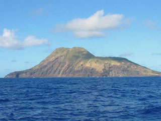
Geological Summary. Sarigan volcano forms an irregular 3-km-long island consisting of a low truncated cone with a 750-m-wide summit crater that contains a small ash cone. The most recent eruptions produced two lava domes from vents above and near the south crater rim. Lava flows from each dome reached the coast and extended out to sea. The northern flow overtopped the crater rim on the N and NW sides. The sparse vegetation on the flows indicated to Meijer and Reagan (1981) that they are of Holocene age.
Information Contacts: R. Moore, USGS; R. Koyanagi, M. Sako, and F. Trusdell, HVO.