Report on Ciremai (Indonesia) — October 2003
Bulletin of the Global Volcanism Network, vol. 28, no. 10 (October 2003)
Managing Editor: Edward Venzke.
Ciremai (Indonesia) Volcanic seismicity that began in March increased in October
Please cite this report as:
Global Volcanism Program, 2003. Report on Ciremai (Indonesia) (Venzke, E., ed.). Bulletin of the Global Volcanism Network, 28:10. Smithsonian Institution. https://doi.org/10.5479/si.GVP.BGVN200310-263170
Ciremai
Indonesia
6.895°S, 108.408°E; summit elev. 3039 m
All times are local (unless otherwise noted)
Data from the Volcanological Survey of Indonesia (VSI) indicated a tectonic and volcanic earthquake at Cereme on 25 March, followed by one more volcanic event on 28 March. Activity picked up on 2 April with three more volcanic events, with 17 events through 14 April. Daily highs of 8 and 11 events were recorded on 24 April and 3 May, respectively (2-4 May had 22). Seismicity remained generally low (0-3/day) until 29 events occurred on 7 October.
After a felt earthquake on 7 October, volcanic earthquakes increased. This increased seismicity was accompanied by elevated visually observed activity, resulting in the hazard status being upgraded to Alert Level 2 on 13 October. Seismic activity during 6-12 October consisted of 46 deep volcanic earthquakes and 15 shallow volcanic earthquakes; 36 deep volcanic events occurred the following week of 13-19 October. There was a felt earthquake on 19 October that lasted for 95.5 seconds (35 mm amplitude). Seismic activity declined during 20-26 October, when only seven deep volcanic earthquakes were recorded. The temperature measured at the Sangkan Hurip hotspring in late October was 48°C, unchanged from previous measurements.
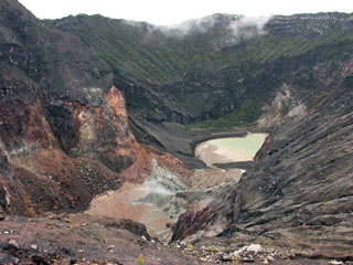
Geological Summary. The symmetrical Ciremai stratovolcano is located closer to the northern coast than other central Java volcanoes. A large crater, elongated in an E-W direction and formed by multiple vents, caps the summit of Gunung Ciremai, which was constructed on the northern rim of the 4.5 x 5 km Geger Halang caldera. A large landslide deposit to the north may be associated with the origin of the caldera, although collapse may rather be due to a voluminous explosive eruption (Newhall and Dzurisin, 1988). Eruptions have included explosive activity and lahars, primarily from the summit crater.
Information Contacts: Dali Ahmad, Hetty Triastuty, Nia Haerani, and Suswati, Volcanological Survey of Indonesia (VSI), Jalan Diponegoro No. 57, Bandung 40122, Indonesia (URL: http://www.vsi.esdm.go.id/); Darwin Volcanic Ash Advisory Centre (VAAC), Bureau of Meteorology, Northern Territory Regional Office, PO Box 40050, Casuarina, NT 0811, Australia (URL: http://www.bom.gov.au/info/vaac/).