Report on Home Reef (Tonga) — November 2023
Bulletin of the Global Volcanism Network, vol. 48, no. 11 (November 2023)
Managing Editor: Kadie Bennis.
Home Reef (Tonga) New eruption with ash plumes and island growth during October 2023
Please cite this report as:
Global Volcanism Program, 2023. Report on Home Reef (Tonga) (Bennis, K.L., ed.). Bulletin of the Global Volcanism Network, 48:11. Smithsonian Institution.
Home Reef
Tonga
18.992°S, 174.775°W; summit elev. -10 m
All times are local (unless otherwise noted)
Home Reef is a submarine volcano located in the central Tonga islands between Lateiki (Metis Shoal) and Late Island. The first recorded eruption occurred in the mid-19th century, when an ephemeral island formed. An eruption in 1984 produced a 12-km-high eruption plume, a large volume of floating pumice, and a 500 x 1,500 m island with 30-50 m high that enclosed a water-filled crater. Another island-forming eruption in 2006 produced widespread pumice rafts that drifted as far as Australia; the island had eroded below the sea after 24 years. The previous eruption occurred during October 2022, which formed a new island above sea level, and more recent activity has consisted of discolored water plumes (BGVN 48:06). This report covers a new eruption that changed the shape of the island during October 2023 and consisted of thermal activity, discolored water plumes, and ash plumes, based on information from the Tonga Geological Services (TGS), the Wellington Volcanic Ash Advisory Center (VAAC), and satellite images.
Activity during May through September dominantly consisted of light yellow-green discolored water plumes proximal to the new island, which were visible in satellite images on clear weather days and extended in different directions (figure 32).
 |
Figure 32. Satellite images showing light yellow-green discolored plumes originating from Home Reef on 22 May 2023 (top left), 17 May 2023 (top right), 21 June 2023 (middle left), 21 July 2023 (middle right), 20 August 2023 (bottom left), and 24 September 2023 (bottom right). Courtesy of Copernicus Browser. |
Activity started to increase during late September through October; MODIS thermal anomaly data provided through MIROVA (Middle InfraRed Observation of Volcanic Activity) showed low-to-moderate strength thermal anomalies during this timeframe (figure 33). According to data from the MODVOLC thermal alerts algorithm, a total of three hotspots were detected on the island on 30 September, 11 October, and 21 October. This thermal activity occurred in conjunction with several eruptive events that occurred throughout the month. Based on a satellite image captured on 10 October at 0059, the island measurements were 424 m N-S and 223 m E-W with an approximate total surface area of roughly 6.9 hectares and an estimated height of 15-18 m above sea level. The island had steep headlands on the E half and a more gradual slope on the W half.
 |
Figure 33. Frequent low-to-moderate strength thermal anomalies were detected at Home Reef beginning in late September and continuing through October 2023, based on this MIROVA graph (Log Radiative Power). This activity was recorded in conjunction with several eruptive events that occurred throughout October. Courtesy of MIROVA. |
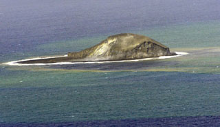
According to the Volcano Water Team from TGS, 11 eruptive events were detected in satellite data during 12-17 October. On 14 October the Aviation Color Code (ACC) was Yellow and the Hazard Alert Level was Orange. A satellite image captured on 14 October showed that estimated dimensions of the island were 480 m N-S and 250 m E-W, an increase from the estimates taken on 10 October (figure 34). According to the Wellington VAAC, a pilot observed an ash plume that rose to less than 300 m altitude on 17 October, although the Tonga Meteorological Services stated that the emissions were mainly composed of steam. An ash cloud detected by the HIMAWARI satellite during 1430-1530 rose to 1-3 km altitude and drifted 70 km from the volcano. Another ash plume reported at 1451 rose to 3 km altitude. On 17 October the ACC was lowered to Green and the Hazard Alert Level was lowered to Yellow. A pilot observed an ash plume that rose to 300 m altitude at 1150 on 18 October. During 21-30 October a total of nine eruptive events were detected in satellite data.
 |
Figure 34. A satellite image of Home Reef taken on 14 October 2023 showing growth of the island compared to previous months. Light yellow-green discolored water plumes continued and extended N from the island. Courtesy of Copernicus Browser. |
Geological Summary. Home Reef, a submarine volcano midway between Metis Shoal and Late Island in the central Tonga islands, was first reported active in the mid-19th century, when an ephemeral island formed. An eruption in 1984 produced a 12-km-high eruption plume, large amounts of floating pumice, and an ephemeral 500 x 1,500 m island, with cliffs 30-50 m high that enclosed a water-filled crater. In 2006 an island-forming eruption produced widespread dacitic pumice rafts that drifted as far as Australia. Another island was built during a September-October 2022 eruption.
Information Contacts: Tonga Geological Services, 51 Vaha'akolo Road, Nuku’alofa, Tonga (URL: https://www.facebook.com/tongageologicalservice); Wellington Volcanic Ash Advisory Centre (VAAC), Meteorological Service of New Zealand Ltd (MetService), PO Box 722, Wellington, New Zealand (URL: http://www.metservice.com/vaac/, http://www.ssd.noaa.gov/VAAC/OTH/NZ/messages.html); MIROVA (Middle InfraRed Observation of Volcanic Activity), a collaborative project between the Universities of Turin and Florence (Italy) supported by the Centre for Volcanic Risk of the Italian Civil Protection Department (URL: http://www.mirovaweb.it/); Hawai'i Institute of Geophysics and Planetology (HIGP) - MODVOLC Thermal Alerts System, School of Ocean and Earth Science and Technology (SOEST), Univ. of Hawai'i, 2525 Correa Road, Honolulu, HI 96822, USA (URL: http://modis.higp.hawaii.edu/); Copernicus Browser, Copernicus Data Space Ecosystem, European Space Agency (URL: https://dataspace.copernicus.eu/browser/).