Report on Bam (Papua New Guinea) — March 1981
Scientific Event Alert Network Bulletin, vol. 6, no. 3 (March 1981)
Managing Editor: Lindsay McClelland.
Bam (Papua New Guinea) Discolored water
Please cite this report as:
Global Volcanism Program, 1981. Report on Bam (Papua New Guinea) (McClelland, L., ed.). Scientific Event Alert Network Bulletin, 6:3. Smithsonian Institution. https://doi.org/10.5479/si.GVP.SEAN198103-251010
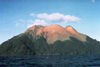
Bam
Papua New Guinea
3.613°S, 144.818°E; summit elev. 685 m
All times are local (unless otherwise noted)
During aerial inspections 6 and 19 March, a 1-km-long zone of orange sea discoloration was noted at the S shore of Bam Island.
Geological Summary. The 1.6 x 2.4 km island of Bam is the summit of a mostly submerged volcano in the Schouten Islands off the coast of New Guinea, ~40 km NNE of the mouth of the Sepik River. A steep-walled summit crater that is 300 m wide and 180 m deep is the source of recent eruptions, which have kept the upper half of the cone sparsely vegetated. A NE-trending landslide scarp extends across the upper part of the andesitic volcano from the SW coast, and a large submarine debris-avalanche deposits lies to the S and SW. The younger summit cone partially buries the eastern side of the collapse scarp. A recent lava platform on the N flank supports the small island's only villages. Eruptions recorded since 1872 have all consisted of small-to-moderate explosive activity from the summit crater.
Information Contacts: Acting Senior Volcanologist, RVO.