Report on Lokon-Empung (Indonesia) — December 1986
Scientific Event Alert Network Bulletin, vol. 11, no. 12 (December 1986)
Managing Editor: Lindsay McClelland.
Lokon-Empung (Indonesia) Continued small explosions and seismicity
Please cite this report as:
Global Volcanism Program, 1986. Report on Lokon-Empung (Indonesia) (McClelland, L., ed.). Scientific Event Alert Network Bulletin, 11:12. Smithsonian Institution. https://doi.org/10.5479/si.GVP.SEAN198612-266100
Lokon-Empung
Indonesia
1.3644°N, 124.7992°E; summit elev. 1580 m
All times are local (unless otherwise noted)
Explosions from Tompaluan Crater continued through early January at rates of 30-80/day. Maximum plume heights were 500-800 m. The Kakaskasen Volcano Observatory recorded 2-20 volcanic earthquakes/day; the average number of events was ~10/day.
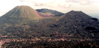
Geological Summary. The Lokong-Empung volcanic complex, rising above the plain of Tondano in North Sulawesi, includes four peaks and an active crater. Lokon, the highest peak, has a flat craterless top. The morphologically younger Empung cone 2 km NE has a 400-m-wide, 150-m-deep crater that erupted last in the 18th century. A ridge extending 3 km WNW from Lokon includes the Tatawiran and Tetempangan peaks. All eruptions since 1829 have originated from Tompaluan, a 150 x 250 m crater in the saddle between Lokon and Empung. These eruptions have primarily produced small-to-moderate ash plumes that sometimes damaged croplands and houses, but lava-dome growth and pyroclastic flows have also occurred.
Information Contacts: VSI.