Report on Tao-Rusyr Caldera (Russia) — April 1987
Scientific Event Alert Network Bulletin, vol. 12, no. 4 (April 1987)
Managing Editor: Lindsay McClelland.
Tao-Rusyr Caldera (Russia) No fumarolic activity
Please cite this report as:
Global Volcanism Program, 1987. Report on Tao-Rusyr Caldera (Russia) (McClelland, L., ed.). Scientific Event Alert Network Bulletin, 12:4. Smithsonian Institution. https://doi.org/10.5479/si.GVP.SEAN198704-290310
Tao-Rusyr Caldera
Russia
49.34°N, 154.725°E; summit elev. 1272 m
All times are local (unless otherwise noted)
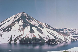
During an aerial survey on 2 November 1986 the summit crater [of Krenitzyn] was covered with snow. There was no indication of fumarolic activity in the summit area or in the area of the 1952 E-flank eruption.
Geological Summary. The southern half of Onekotan Island in the northern Kuril Islands contains the 7.5-km-wide Tao-Rusyr caldera, which is mostly filled by Kal'tsevoe lake. The basaltic-to-andesitic caldera formed about 7,500 years ago, in which the large post-caldera Krenitsyn Peak grew, building a 4-km-wide island in the NW part of the lake that rises above the caldera rim. A 350-m-wide, 100-m-deep crater truncates the peak, and a large crater is located on the upper NE side. An eruption in 1952 formed a small lava dome in an explosion crater along the eastern shore of the island.
Information Contacts: G. Steinberg and B. Piskunov, Yuzhno-Sakhalinsk.