Report on Raoul Island (New Zealand) — 13 September-19 September 2006
Smithsonian Institution / US Geological Survey
Weekly Volcanic Activity Report, 13 September-19 September 2006
Managing Editor: Sally Sennert.
Please cite this report as:
Global Volcanism Program, 2006. Report on Raoul Island (New Zealand) (Sennert, S, ed.). Weekly Volcanic Activity Report, 13 September-19 September 2006. Smithsonian Institution and US Geological Survey.
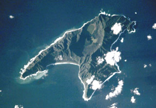
Raoul Island
New Zealand
29.27°S, 177.92°W; summit elev. 516 m
All times are local (unless otherwise noted)
The Alert Level at Raoul Island was lowered to 0 (on a scale of 0-5) on 18 September due to a general decline in activity. Since April 2006, no significant earthquake activity had occurred within ~30 km of the island, the water in Green Lake dropped to the pre-eruption level, and on-going hydrothermal activity returned to normal.
Geological Summary. Anvil-shaped Raoul Island is the largest and northernmost of the Kermadec Islands. During the past several thousand years volcanism has been dominated by dacitic explosive eruptions. Two Holocene calderas exist, the older of which cuts the center the island and is about 2.5 x 3.5 km wide. Denham caldera, formed during a major dacitic explosive eruption about 2200 years ago, truncated the W side of the island and is 6.5 x 4 km wide. Its long axis is parallel to the tectonic fabric of the Havre Trough that lies W of the volcanic arc. Historical eruptions during the 19th and 20th centuries have sometimes occurred simultaneously from both calderas, and have consisted of small-to-moderate phreatic eruptions, some of which formed ephemeral islands in Denham caldera. An unnamed submarine cone, one of several located along a fissure on the lower NNE flank, has also erupted during historical time, and satellitic vents are concentrated along two parallel NNE-trending lineaments.
Source: GeoNet