Report on Chaiten (Chile) — 21 May-27 May 2008
Smithsonian Institution / US Geological Survey
Weekly Volcanic Activity Report, 21 May-27 May 2008
Managing Editor: Sally Sennert.
Please cite this report as:
Global Volcanism Program, 2008. Report on Chaiten (Chile) (Sennert, S, ed.). Weekly Volcanic Activity Report, 21 May-27 May 2008. Smithsonian Institution and US Geological Survey.
Chaiten
Chile
42.8349°S, 72.6514°W; summit elev. 1122 m
All times are local (unless otherwise noted)
Based on observations of satellite imagery and pilot reports, the Buenos Aires VAAC reported that during 21 and 23-27 May ash plumes from Chaitén rose to altitudes of 3-6.4 km (10,000-21,000 ft) a.s.l. and drifted N, NE, E, and SE. Cloudy conditions occasionally inhibited observations. A thermal anomaly was present on 26 May.
During aerial observations on 21 May, SERNAGEOMIN scientists observed a new lava dome that formed in the interior of an active crater on the N flank of the older lava dome. Explosions from the new lava dome generated reddish plumes and small pyroclastic flows that descended the N flank. Steam plumes were emitted from the western part of the dome. Eruption plumes generated from an area in the S part of the active crater drifted SE. The Alert level remained at Red. An overflight conducted on 24 May revealed that the lava dome had grown slightly and was just above the top of the old dome. A crater about 200 m in diameter S of the new dome emitted ash and gas. Block-and-ash flows traveled mostly N. Many of the areas rivers were gray with ash and pumice. Lahars along the Chaitén river continued to affect Chaitén town. During 24-25 May, ash plumes rose to an approximate altitude of 4.6 km (15,100 ft) a.s.l.; explosions occasionally propelled the gas-and-ash column to an altitude of 6.1 km (20,000 ft) a.s.l.
SERNAGEOMIN reported that during 23-26 May, the number and intensity of seismic events decreased, and explosions were less powerful and produced smaller volumes of material. On 25 May, ONEMI reported that the 50-km high-risk zone was reduced to 24 km due to the decrease in activity. Residents were permitted to retrieve property and animals from within the high-risk zone.
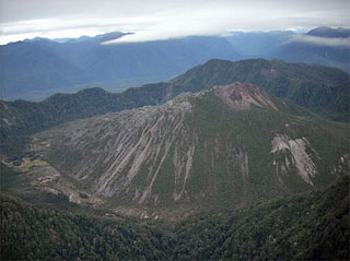
Geological Summary. Chaitén is a small caldera (~3 km in diameter) located 10 km NE of the town of Chaitén on the Gulf of Corcovado. Multiple explosive eruptions throughout the Holocene have been identified. A rhyolitic obsidian lava dome occupies much of the caldera floor. Obsidian cobbles from this dome found in the Blanco River are the source of artifacts from archaeological sites along the Pacific coast as far as 400 km from the volcano to the N and S. The caldera is breached on the SW side by a river that drains to the bay of Chaitén. The first recorded eruption, beginning in 2008, produced major rhyolitic explosive activity and building a new dome and tephra cone on the older rhyolite dome.
Sources: Buenos Aires Volcanic Ash Advisory Center (VAAC), Servicio Nacional de Geología y Minería (SERNAGEOMIN), Oficina Nacional de Emergencia-Ministerio del Interior (ONEMI)

