Report on Machin (Colombia) — 5 November-11 November 2008
Smithsonian Institution / US Geological Survey
Weekly Volcanic Activity Report, 5 November-11 November 2008
Managing Editor: Sally Sennert.
Please cite this report as:
Global Volcanism Program, 2008. Report on Machin (Colombia) (Sennert, S, ed.). Weekly Volcanic Activity Report, 5 November-11 November 2008. Smithsonian Institution and US Geological Survey.
Machin
Colombia
4.487°N, 75.389°W; summit elev. 2749 m
All times are local (unless otherwise noted)
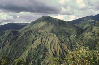
Observatory Vulcanológico and Sismológico de Manizales reported a seismic crisis at Cerro Machín on 9 November. The majority of the earthquakes occurred underneath the central and E parts of the lava dome complex in the summit caldera, at depths of 2.5-5 km. Fumarolic activity in the area increased, and cracks in the ground and damage to houses were reported. Seismicity decreased the next day. According to news articles, approximately 400-450 people evacuated to shelters or other safe areas and landslides blocked a highway.
Geological Summary. The small Cerro Machín stratovolcano lies at the southern end of the Ruiz-Tolima massif about 20 km WNW of the city of Ibagué. A 3-km-wide caldera is breached to the south and contains three forested dacitic lava domes. Voluminous pyroclastic flows traveled up to 40 km away during eruptions in the mid-to-late Holocene, perhaps associated with formation of the caldera. Late-Holocene eruptions produced dacitic block-and-ash flows that traveled through the breach in the caldera rim to the west and south. The latest known eruption of took place about 800 years ago.
Sources: Servicio Geológico Colombiano (SGC), Caracol Radio, Portafolio, El Tiempo