Report on Eyjafjallajokull (Iceland) — 7 April-13 April 2010
Smithsonian Institution / US Geological Survey
Weekly Volcanic Activity Report, 7 April-13 April 2010
Managing Editor: Sally Sennert.
Please cite this report as:
Global Volcanism Program, 2010. Report on Eyjafjallajokull (Iceland) (Sennert, S, ed.). Weekly Volcanic Activity Report, 7 April-13 April 2010. Smithsonian Institution and US Geological Survey.
Eyjafjallajokull
Iceland
63.633°N, 19.633°W; summit elev. 1651 m
All times are local (unless otherwise noted)
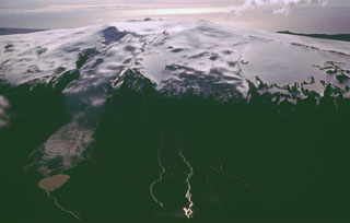
The Institute of Earth Sciences reported that on 7 April the eruption from Eyjafjöll ceased from the original eruption craters and was limited to the fissure that had opened on 31 March. Lava flows covered an estimated area of 1.3 square kilometers and were on average 10-20 m thick. The largest scoria cone was 82 m high. After minor changes in deformation rates during the eruption, on 9 April deformation returned to pre-eruption levels. Eruptive activity was observed on 11 April, but tremor decreased to baseline the next day. Also on 12 April, according to a new article, the Icelandic Civil Protection Department decided to lower the preparedness level by one point, from emergency to danger because of the decreasing activity. Another article stated that a pilot saw no active lava flows, only steam plumes, during an overflight on 13 April.
At 2300 on 13 April, a seismic swarm was detected below the central part of Eyjafjöll, W of the previous eruption fissures. About an hour later, the onset of seismic tremor heralded an eruption from a new vent on the S rim of the central caldera, capped by Eyjafjallajökull glacier. The eruption was visually confirmed early in the morning on 14 April; an eruption plume rose at least 8 km above the glacier. Meltwater flowed to the N and S. News outlets reported that a circular ice-free area about 200 m in diameter was seen near the summit. Scientists conducting an overflight saw a new 2-km-long, N-S-trending fissure, and ashfall to the E. About 700 people were ordered to evacuate the area, and certain flights were banned from flying N and E of the eruption area. Flooding increased throughout the day, causing road closures and some structural damage.
Geological Summary. Eyjafjallajökull (also known as Eyjafjöll) is located west of Katla volcano. It consists of an elongated ice-covered stratovolcano with a 2.5-km-wide summit caldera. Fissure-fed lava flows occur on both the E and W flanks, but are more prominent on the western side. Although the volcano has erupted during historical time, it has been less active than other volcanoes of Iceland's eastern volcanic zone, and relatively few Holocene lava flows are known. An intrusion beneath the S flank from July-December 1999 was accompanied by increased seismic activity. The last historical activity prior to an eruption in 2010 produced intermediate-to-silicic tephra from the central caldera during December 1821 to January 1823.
Sources: Institute of Earth Sciences, Icelandic Meteorological Office (IMO), Iceland Review