Report on Eyjafjallajokull (Iceland) — 21 April-27 April 2010
Smithsonian Institution / US Geological Survey
Weekly Volcanic Activity Report, 21 April-27 April 2010
Managing Editor: Sally Sennert.
Please cite this report as:
Global Volcanism Program, 2010. Report on Eyjafjallajokull (Iceland) (Sennert, S, ed.). Weekly Volcanic Activity Report, 21 April-27 April 2010. Smithsonian Institution and US Geological Survey.
Eyjafjallajokull
Iceland
63.633°N, 19.633°W; summit elev. 1651 m
All times are local (unless otherwise noted)
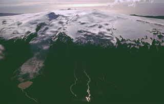
The Institute of Earth Sciences at the Nordic Volcanological Center (NVC) reported that the summit eruption from Eyjafjallajökull continued during 21-27 April. The eruption rate on 21 April was inferred to have been an order of magnitude smaller than during the initial 72 hours of the eruption, having declined over the previous few days. Phreatomagmatic activity with some lava spatter occurred from the northernmost of two craters in the summit caldera, generating plumes to an altitude of 3 km (9,800 ft) a.s.l. that drifted S. The emission of lava flows likely began around 1200 evident by the onset of semi-continuous meltwater discharge, steaming from the N edge of the ice cauldron, and changes in tremor amplitude.
Similar activity continued for the next four days, although plumes sometimes rose to 6 km (19,700 ft) a.s.l. on 22 April. On 23 April changes in the wind direction pushed the plume NW, causing airports in SW Iceland to close. The next day, mild explosive activity ejected spatter 100 m above the crater and shockwaves were detected every few seconds; an ash plume rose 4 km (13,100 ft) a.s.l. and drifted SW. A depression in the ice, formed from lava flows that had advanced 400-500 m N of the crater, was 700 m long and steaming, especially at the edges.
The N crater was active on 25 April. The eruption plume height was unknown due to meteorological cloud cover at 5.3 km (17,400 ft) a.s.l.; minor ashfall was noted at two farms 10 km NW of the vents. Explosions were also heard at locations 10-15 km NW. On 26 April plumes rose to an average altitude of 4.8 km (15,700 ft) a.s.l. and drifted E. Radar data showed a tephra crater or cone continuously building on the N crater. The structure was approximately 150 m high and 200 m wide. According to news articles, flights from Iceland's airports resumed.
On 27 April NVC reported that the eruption plume was seen during an overflight, and rose to altitudes of 3-3.6 km (10,000-11,800 ft) a.s.l. and drifted WNW. Light ashfall was noted in inhabited areas between 32 and 45 km W. Scientists also saw that a new crater had formed in the SW part of the caldera; the rim was about 50 m lower than the surrounding ice surface. Ash plumes rose from the vent and spatter was ejected 100-200 m above the vent. The lava flow front had advanced 1 km N from the vents. Flights from Iceland's airports were again disrupted.
Geological Summary. Eyjafjallajökull (also known as Eyjafjöll) is located west of Katla volcano. It consists of an elongated ice-covered stratovolcano with a 2.5-km-wide summit caldera. Fissure-fed lava flows occur on both the E and W flanks, but are more prominent on the western side. Although the volcano has erupted during historical time, it has been less active than other volcanoes of Iceland's eastern volcanic zone, and relatively few Holocene lava flows are known. An intrusion beneath the S flank from July-December 1999 was accompanied by increased seismic activity. The last historical activity prior to an eruption in 2010 produced intermediate-to-silicic tephra from the central caldera during December 1821 to January 1823.
Sources: Associated Press, Institute of Earth Sciences, Iceland Review