Report on Eyjafjallajokull (Iceland) — 27 October-2 November 2010
Smithsonian Institution / US Geological Survey
Weekly Volcanic Activity Report, 27 October-2 November 2010
Managing Editor: Sally Sennert.
Please cite this report as:
Global Volcanism Program, 2010. Report on Eyjafjallajokull (Iceland) (Sennert, S, ed.). Weekly Volcanic Activity Report, 27 October-2 November 2010. Smithsonian Institution and US Geological Survey.
Eyjafjallajokull
Iceland
63.633°N, 19.633°W; summit elev. 1651 m
All times are local (unless otherwise noted)
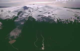
According to a news article from 27 October, a scientist at the University of Iceland Institute of Earth Sciences noted that the eruption of Eyjafjallajökull, that began as a fissure eruption on 20 March 2010 and later continued from the summit caldera on 14 April, was over. Ash was last seen rising from the caldera in June.
Geological Summary. Eyjafjallajökull (also known as Eyjafjöll) is located west of Katla volcano. It consists of an elongated ice-covered stratovolcano with a 2.5-km-wide summit caldera. Fissure-fed lava flows occur on both the E and W flanks, but are more prominent on the western side. Although the volcano has erupted during historical time, it has been less active than other volcanoes of Iceland's eastern volcanic zone, and relatively few Holocene lava flows are known. An intrusion beneath the S flank from July-December 1999 was accompanied by increased seismic activity. The last historical activity prior to an eruption in 2010 produced intermediate-to-silicic tephra from the central caldera during December 1821 to January 1823.
Source: Iceland Review