Report on Nabro (Eritrea) — 28 September-4 October 2011
Smithsonian Institution / US Geological Survey
Weekly Volcanic Activity Report, 28 September-4 October 2011
Managing Editor: Sally Sennert.
Please cite this report as:
Global Volcanism Program, 2011. Report on Nabro (Eritrea) (Sennert, S, ed.). Weekly Volcanic Activity Report, 28 September-4 October 2011. Smithsonian Institution and US Geological Survey.
Nabro
Eritrea
13.37°N, 41.7°E; summit elev. 2218 m
All times are local (unless otherwise noted)
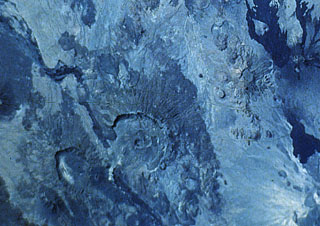
According to NASA's Earth Observatory, satellite images of Nabro acquired on 28 September showed heat from the vent in the central crater, and from an area 1.3 km S of the vent that indicated an active lava flow. A small and diffuse plume rose from the vent. A region of seemingly thicker black ash (that completely covered the sparse vegetation) was noted S of the crater and thinner layers of ash (with some areas of visible vegetation) flanked either side of the region.
Geological Summary. The Nabro stratovolcano is the highest volcano in the Danakil depression of northern Ethiopia and Eritrea, at the SE end of the Danakil Alps. Nabro, along with Mallahle, Asavyo, and Sork Ale volcanoes, collectively comprise the Bidu volcanic complex SW of Dubbi volcano. This complex stratovolcano constructed primarily of trachytic lava flows and pyroclastics, is truncated by nested calderas 8 and 5 km in diameter. The larger caldera is widely breached to the SW. Rhyolitic obsidian domes and basaltic lava flows were erupted inside the caldera and on its flanks. Some very recent lava flows were erupted from NNW-trending fissures transverse to the trend of the volcanic range.
Source: NASA Earth Observatory