Report on Little Sitkin (United States) — 9 January-15 January 2013
Smithsonian Institution / US Geological Survey
Weekly Volcanic Activity Report, 9 January-15 January 2013
Managing Editor: Sally Sennert.
Please cite this report as:
Global Volcanism Program, 2013. Report on Little Sitkin (United States) (Sennert, S, ed.). Weekly Volcanic Activity Report, 9 January-15 January 2013. Smithsonian Institution and US Geological Survey.
Little Sitkin
United States
51.95°N, 178.543°E; summit elev. 1174 m
All times are local (unless otherwise noted)
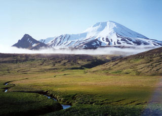
On 9 January, AVO reported that unrest at Little Sitkin had decreased over the past several months, reaching background levels. The Volcano Alert Level was lowered to Normal and the Aviation Color Code was lowered to Green.
Geological Summary. Diamond-shaped Little Sitkin Island is bounded by steep cliffs on the east, north, and NE sides. Little Sitkin volcano contains two nested calderas. The older, nearly circular Pleistocene caldera is 4.8 km wide, may have once contained a caldera lake, and was partially filled by a younger cone formed mostly of andesitic and dacitic lava flows. The elliptical younger caldera is 2.7 x 4 km wide; it lies within the eastern part of the older caldera and shares its eastern and southern rim. The younger caldera partially destroyed the lava cone within the first caldera and is of possible early Holocene age. Young-looking dacitic lava flows, erupted in 1828 (Kay, in Wood and Kienle 1990), issued from the central cone within the younger caldera and from a vent on the west flank outside the older caldera. Fumarolic areas are found near the western coast, along the NW margin of the older caldera, and from the summit crater down the southern flank for a 1 km distance.
Source: US Geological Survey Alaska Volcano Observatory (AVO)