Report on San Miguel (El Salvador) — 9 April-15 April 2014
Smithsonian Institution / US Geological Survey
Weekly Volcanic Activity Report, 9 April-15 April 2014
Managing Editor: Sally Sennert.
Please cite this report as:
Global Volcanism Program, 2014. Report on San Miguel (El Salvador) (Sennert, S, ed.). Weekly Volcanic Activity Report, 9 April-15 April 2014. Smithsonian Institution and US Geological Survey.
San Miguel
El Salvador
13.434°N, 88.269°W; summit elev. 2130 m
All times are local (unless otherwise noted)
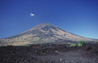
According to SNET, the Ministerio de Medio Ambiente y Recursos Naturales (MARN) reported that on 12 April moderate to strong gas plumes from San Miguel rose from the crater and drifted SW. The most robust plume occurred at 1607 and rose 400 m. Images recorded by a webcam showed that the plumes had dark tones, suggesting small amounts of ash.
Geological Summary. The symmetrical cone of San Miguel, one of the most active volcanoes in El Salvador, rises from near sea level to form one of the country's most prominent landmarks. A broad, deep, crater complex that has been frequently modified by eruptions recorded since the early 16th century caps the truncated unvegetated summit, also known locally as Chaparrastique. Flanks eruptions of the basaltic-andesitic volcano have produced many lava flows, including several during the 17th-19th centuries that extended to the N, NE, and SE. The SE-flank flows are the largest and form broad, sparsely vegetated lava fields crossed by highways and a railroad skirting the base of the volcano. Flank vent locations have migrated higher on the edifice during historical time, and the most recent activity has consisted of minor ash eruptions from the summit crater.