Report on Fogo (Cabo Verde) — 18 February-24 February 2015
Smithsonian Institution / US Geological Survey
Weekly Volcanic Activity Report, 18 February-24 February 2015
Managing Editor: Sally Sennert.
Please cite this report as:
Global Volcanism Program, 2015. Report on Fogo (Cabo Verde) (Sennert, S, ed.). Weekly Volcanic Activity Report, 18 February-24 February 2015. Smithsonian Institution and US Geological Survey.
Fogo
Cabo Verde
14.95°N, 24.35°W; summit elev. 2829 m
All times are local (unless otherwise noted)
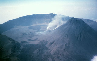
The Observatório Vulcanológico de Cabo Verde (OVCV) reported that on 8 February the eruption at Fogo had ended; sulfur dioxide emissions were almost undetectable on 8 February and continued to remain so at least through 11 February. During that period, pahoehoe flows remained stagnant and only minor fumarolic activity was present at the edge of the new crater. In addition, since 7 February, temperatures of the fumaroles and of an area at the base of the cone had decreased significantly.
Geological Summary. The island of Fogo consists of a single massive stratovolcano that is the most prominent of the Cape Verde Islands. The roughly circular 25-km-wide island is truncated by a large 9-km-wide caldera that is breached to the east and has a headwall 1 km high. The caldera is located asymmetrically NE of the center of the island and was formed as a result of massive lateral collapse of the older Monte Armarelo edifice. A very youthful steep-sided central cone, Pico, rises more than 1 km above the caldera floor to about 100 m above the rim. Pico, which is capped by a 500-m-wide, 150-m-deep summit crater, was apparently in almost continuous activity from the time of Portuguese settlement in 1500 CE until around 1760. Later lava flows, some from vents on the caldera floor, reached the eastern coast below the breached caldera.
Source: Universidade of Cabo Verde