Report on Batu Tara (Indonesia) — 20 May-26 May 2015
Smithsonian Institution / US Geological Survey
Weekly Volcanic Activity Report, 20 May-26 May 2015
Managing Editor: Sally Sennert.
Please cite this report as:
Global Volcanism Program, 2015. Report on Batu Tara (Indonesia) (Sennert, S, ed.). Weekly Volcanic Activity Report, 20 May-26 May 2015. Smithsonian Institution and US Geological Survey.
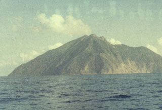
Batu Tara
Indonesia
7.791°S, 123.585°E; summit elev. 633 m
All times are local (unless otherwise noted)
Based on analyses of satellite imagery and wind data, the Darwin VAAC reported that during 21-22 May ash plumes from Batu Tara rose to an altitude of 2.5 km (8,000 ft) a.s.l. and drifted over 80 km W.
Geological Summary. The small isolated island of Batu Tara in the Flores Sea ~50 km N of Lembata (fomerly Lomblen) Island and the main volcanic arc. A scarp on the eastern side reaches the sea, and vegetation covers the other flanks to within 50 m of the summit. This volcano is noted for its potassic leucite-bearing basanitic and tephritic rocks. The first recorded eruption, during 1847-52, produced explosions and a lava flow.