Report on Concepcion (Nicaragua) — 27 May-2 June 2015
Smithsonian Institution / US Geological Survey
Weekly Volcanic Activity Report, 27 May-2 June 2015
Managing Editor: Sally Sennert.
Please cite this report as:
Global Volcanism Program, 2015. Report on Concepcion (Nicaragua) (Sennert, S, ed.). Weekly Volcanic Activity Report, 27 May-2 June 2015. Smithsonian Institution and US Geological Survey.
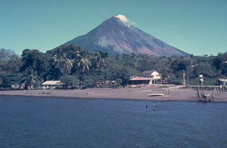
Concepcion
Nicaragua
11.538°N, 85.622°W; summit elev. 1700 m
All times are local (unless otherwise noted)
INETER noted that 159-177 gas explosions had been detected during 27 May-1 June, bringing the total number to 1,493 detected by the network since an unspecified date of increased activity.
Geological Summary. Volcán Concepción is a symmetrical basaltic-to-dacitic stratovolcano that forms the NW half of the dumbbell-shaped island of Ometepe in Lake Nicaragua and is connected to neighboring Madera volcano by a narrow isthmus. A steep-walled summit crater is 250 m deep and has a higher western rim. N-S-trending fractures on the flanks have produced chains of spatter cones, cinder cones, lava domes, and maars located on the NW, NE, SE, and southern sides extending in some cases down to Lake Nicaragua. It was constructed above a basement of lake sediments, and the modern cone grew above a largely buried caldera, a small remnant of which forms a break in slope about halfway up the N flank. Frequent explosive eruptions during the past half century have increased the height of the summit significantly and have kept the upper part of the volcano unvegetated.
Source: Instituto Nicaragüense de Estudios Territoriales (INETER)