Report on Axial Seamount (Undersea Features) — 2 September-8 September 2015
Smithsonian Institution / US Geological Survey
Weekly Volcanic Activity Report, 2 September-8 September 2015
Managing Editor: Sally Sennert.
Please cite this report as:
Global Volcanism Program, 2015. Report on Axial Seamount (Undersea Features) (Sennert, S, ed.). Weekly Volcanic Activity Report, 2 September-8 September 2015. Smithsonian Institution and US Geological Survey.
Axial Seamount
Undersea Features
45.95°N, 130°W; summit elev. -1410 m
All times are local (unless otherwise noted)
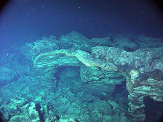
An eruption at Axial Seamount, inferred to have started at 2230 on 23 April with an earthquake swarm, was confirmed during 14-29 August by bathymetric data and observations made during a ROV Jason dive. Two large lava flows from the N rift zone (8-16 km N of the summit caldera) were at most 127 m thick; some of the thicker areas had drained collapse features indicating they had molten interiors when emplaced. The ROV traversed the flows for about 2 km. New, thinner lava flows were also identified in the NE summit caldera and on the NE rim.
Geological Summary. Axial Seamount rises 700 m above the mean level of the central Juan de Fuca Ridge crest about 480 km W of Cannon Beach, Oregon, to within about 1,400 m of the ocean surface. It is the most magmatically and seismically active site on the Juan de Fuca Ridge between the Blanco Fracture Zone and the Cobb offset. The summit is marked by an unusual rectangular-shaped caldera (3 x 8 km) that lies between two rift zones and is estimated to have formed about 31,000 years ago. The caldera is breached to the SE and is defined on three sides by boundary faults of up to 150 m relief. Hydrothermal vents with biological communities are located near the caldera fault and along the rift zones. Hydrothermal venting was discovered north of the caldera in 1983. Detailed mapping and sampling efforts have identified more than 50 lava flows emplaced since about 410 CE (Clague et al., 2013). Eruptions producing fissure-fed lava flows that buried previously installed seafloor instrumentation were detected seismically and geodetically in 1998 and 2011, and confirmed shortly after each eruption during submersible dives.
Source: Oregon State University's Marine Science Center and NOAA/PMEL EOI Program