Report on Cleveland (United States) — 30 September-6 October 2015
Smithsonian Institution / US Geological Survey
Weekly Volcanic Activity Report, 30 September-6 October 2015
Managing Editor: Sally Sennert.
Please cite this report as:
Global Volcanism Program, 2015. Report on Cleveland (United States) (Sennert, S, ed.). Weekly Volcanic Activity Report, 30 September-6 October 2015. Smithsonian Institution and US Geological Survey.
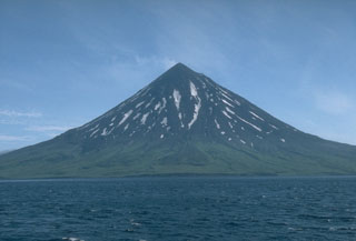
Cleveland
United States
52.825°N, 169.944°W; summit elev. 1730 m
All times are local (unless otherwise noted)
AVO reported that during 30 September-6 October low-level unrest at Cleveland likely continued. Weakly elevated surface temperatures were detected in satellite images during 29-30 September. Minor steaming was recorded by the webcam on 1 October. The Aviation Color Code remained at Orange and the Volcano Alert Level remained at Watch.
Geological Summary. The symmetrical Mount Cleveland stratovolcano is situated at the western end of the uninhabited Chuginadak Island. It lies SE across Carlisle Pass strait from Carlisle volcano and NE across Chuginadak Pass strait from Herbert volcano. Joined to the rest of Chuginadak Island by a low isthmus, The native name, Chuginadak, refers to the Aleut goddess of fire, who was thought to reside on the volcano. Numerous large lava flows descend the steep-sided flanks. It is possible that some 18th-to-19th century eruptions attributed to Carlisle should be ascribed to Cleveland (Miller et al., 1998). In 1944 it produced the only known fatality from an Aleutian eruption.
Source: US Geological Survey Alaska Volcano Observatory (AVO)