Report on Egon (Indonesia) — 27 January-2 February 2016
Smithsonian Institution / US Geological Survey
Weekly Volcanic Activity Report, 27 January-2 February 2016
Managing Editor: Sally Sennert.
Please cite this report as:
Global Volcanism Program, 2016. Report on Egon (Indonesia) (Sennert, S, ed.). Weekly Volcanic Activity Report, 27 January-2 February 2016. Smithsonian Institution and US Geological Survey.
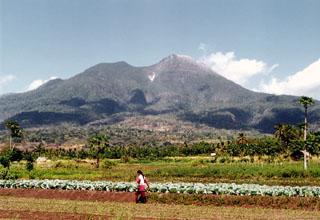
Egon
Indonesia
8.676°S, 122.455°E; summit elev. 1661 m
All times are local (unless otherwise noted)
PVMBG reported that during 20 January-1 February seismicity at Egon was dominated by signals indicating emissions; shallow volcanic events had decreased. RSAM values increased on 25 January but did not exceed values detected during the previous peak on 12 January; overall seismicity had declined. The Alert Level was lowered to 2 (on a scale of 1-4) and residents were advised to stay at least 1.5 km away from the crater.
Geological Summary. Gunung Egon, also known as Namang, sits within the narrow section of eastern Flores Island. The barren, sparsely vegetated summit region has a 350-m-wide, 200-m-deep crater that sometimes contains a lake. Other small crater lakes occur on the flanks. A lava dome forms the southern summit. Solfataric activity occurs on the crater wall and rim and on the upper S flank. Reports of eruptive activity prior to explosive eruptions beginning in 2004 are unconfirmed. Emissions were often observed above the summit during 1888-1892. Strong emissions in 1907 reported by Sapper (1917) was considered by the Catalog of Active Volcanoes of the World (Neumann van Padang, 1951) to be an historical eruption, but Kemmerling (1929) noted that this was likely confused with an eruption on the same date and time from Lewotobi Lakilaki.
Source: Pusat Vulkanologi dan Mitigasi Bencana Geologi (PVMBG, also known as CVGHM)