Report on Okataina (New Zealand) — 15 June-21 June 2016
Smithsonian Institution / US Geological Survey
Weekly Volcanic Activity Report, 15 June-21 June 2016
Managing Editor: Sally Sennert.
Please cite this report as:
Global Volcanism Program, 2016. Report on Okataina (New Zealand) (Sennert, S, ed.). Weekly Volcanic Activity Report, 15 June-21 June 2016. Smithsonian Institution and US Geological Survey.
Okataina
New Zealand
38.1569°S, 176.5069°E; summit elev. 1111 m
All times are local (unless otherwise noted)
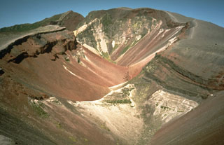
GeoNet reported that the Mud Rift feature at Okataina's Waimangu Geothermal area erupted during 17-20 May, the first time since 1989. The Mud Rift geothermal vent formed in 1906 in the Raupo Pond Crater (one of multiple craters which formed in June 1886) and is 36 m long, 5-6 m wide, and 15 m deep. The steam-driven events mostly ejected fine sand and mud, and there was abundant evidence of fluids flooding into the rift, especially at the W end. Nearby vegetation was brown, and there was some evidence of collapse around the edges of the vents.
Geological Summary. The massive, dominantly rhyolitic Okataina Volcanic Centre (OVC) is surrounded by extensive ignimbrite and pyroclastic sheets produced during multiple caldera-forming eruptions. Numerous lava domes and craters erupted from two subparallel NE-SW-trending vent lineations form the Haroharo and Tarawera volcanic complexes. Lava domes of the Haroharo complex, at the northern end of the OVC, occupy part of the 16 x 26 km Pleistocene Haroharo caldera, which formed incrementally between 300,000 and 50,000 years before present (BP). The oldest exposed rocks on the caldera floor are about 22,000 years old. The Tarawera complex at the southern end of OVC consists of 11 rhyolitic lava domes and associated lava flows. The oldest domes were formed as late as about 15,000 years BP, and the youngest were formed in the Kaharoa eruption about 800 years BP. The NE-SW Tarawera vent lineation extends from the two dacitic cones of Maungaongaonga and Mangakakaramea on the SW to Mount Edgecumbe on the NE. Construction of the Haroharo and Tarawera complexes impounded lakes Rotoiti, Totoehu, Okataina, and Tarawera against the outer margins of the Okataina ring structure. A major hydrothermal area is located at Waimangu; the world-renowned Pink and White Terrace siliceous sinter deposits were destroyed during the major basaltic explosive eruption of 1886.
Source: GeoNet