Report on Zavodovski (United Kingdom) — 29 June-5 July 2016
Smithsonian Institution / US Geological Survey
Weekly Volcanic Activity Report, 29 June-5 July 2016
Managing Editor: Sally Sennert.
Please cite this report as:
Global Volcanism Program, 2016. Report on Zavodovski (United Kingdom) (Sennert, S, ed.). Weekly Volcanic Activity Report, 29 June-5 July 2016. Smithsonian Institution and US Geological Survey.
Zavodovski
United Kingdom
56.3°S, 27.57°W; summit elev. 551 m
All times are local (unless otherwise noted)
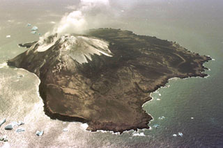
On 30 March an eruption at Zavodovski was reported and photographed by observers on a fishing vessel, as well as captured by a satellite image. A small ash plume drifted E, producing ashfall on 1/3 to 1/2 of the island. A photo showed bombs being ejected from the crater. One of the world’s largest (if not the largest) penguin colonies resides on the E side of the island and is home to 690,000 breeding pairs. The eruption occurred during molting season in March, when penguins stay ashore. A satellite image captured in May showed an eruption plume coming through the clouds.
Geological Summary. The 5-km-wide Zavodovski Island, the northernmost of the South Sandwich Islands, consists of a single basaltic stratovolcano with two cones on the east side. Mount Curry, the island's summit, lies west of the center of the island, which is more eroded on that side. Two fissures extend NE from the summit towards the E-flank craters, and a lava platform is located along the eastern coast. The volcano was producing abundant emissions when observed in 1819 by the explorer Bellingshausen. A landing party in 1830 also reported strong emissions along with a fresh lava field on the east side from which pumice was being eroded into the ocean.
Source: Peter Fretwell, British Antarctic Survey, personal communication