Report on Unnamed (Tonga) — 25 January-31 January 2017
Smithsonian Institution / US Geological Survey
Weekly Volcanic Activity Report, 25 January-31 January 2017
Managing Editor: Sally Sennert.
Please cite this report as:
Global Volcanism Program, 2017. Report on Unnamed (Tonga) (Sennert, S, ed.). Weekly Volcanic Activity Report, 25 January-31 January 2017. Smithsonian Institution and US Geological Survey.
Unnamed
Tonga
20.852°S, 175.55°W; summit elev. -296 m
All times are local (unless otherwise noted)
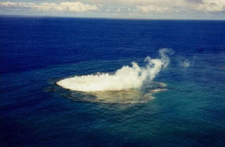
Based on analysis of satellite images, GeoNet reported that a submarine eruption at an Unnamed volcano (GVP volcano number 243030) about 46 km NW of Tonga’s capital Nuku’alofa began on 23 January. Activity was also identified in images from 26, 28, 29, and 31 January, characterized by discolored water, and a volcanic plume on 31 January.
Geological Summary. An unnamed submarine volcano is located along the Tofus volcanic arc 35 km NW of the Niu Aunofo lighthouse on Tongatapu Island. The first documented eruptions took place in 1911 and 1923; an ephemeral island was formed in 1999. A submarine eruption in January 2017 produced discolored water visible in satellite imagery.
Source: GeoNet